In the previous section we have described the results from using self-organizing maps with the data of the CIA World Factbook. The major shortcoming of this neural network model is that the various documents are represented within only one two-dimensional output space making it difficult to identify cluster boundaries without profound insight into the underlying document collection.
The hierarchical feature map can provide essential assistance in isolating the different clusters. The isolation of clusters is achieved thanks to the architecture of the neural network which consists of layers of independent self-organizing maps. Thus, in the highest layer the complete document archive is represented by means of a small map (in terms of the number of neural processing elements). Each unit is then further developed within its own branch of the neural network.
For the experiment presented thereafter we used a setup of the
hierarchical feature map using four layers.
The respective maps have the following dimensions:
![]() on the first layer,
on the first layer,
![]() on the second layer,
and
on the second layer,
and
![]() on the third and fourth layer.
This setup has been determined empirically.
on the third and fourth layer.
This setup has been determined empirically.
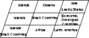
Figure 4 presents the contents of the first layer self-organizing map. In order to keep the information at a minimum we refrained from typing the names of the various countries in this figure. We rather present some aggregated information concerning the geographical location of the various countries.
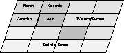
In the remainder of this discussion we will just present the branch of the hierarchical feature map that contains what we called economically developed countries. The other branches cannot be shown in this paper because of space considerations. These branches, however, are formed quite similarly.
In Figure 5 we show the arrangement of the second layer within the branch of economically developed countries. In this map, the various countries are separated roughly according to either their geographic location or their political system. The clusters are symbolized by using different shades of grey.
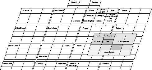
Finally, Figure 6 shows the full-blown branch of economically developed countries. In this case it is straight-forward to identify the various cluster boundaries in that each cluster is represented by an individual self-organizing map. Higher level similarities are shown in higher levels of the hierarchical feature map.